
Make a donation
Gear up for your next adventure:
As an Amazon Associate, this site earns from qualifying purchases at no extra cost to you.
Raveo topographic map
Click on the map to display elevation.
Make a donation
Gear up for your next adventure:
As an Amazon Associate, this site earns from qualifying purchases at no extra cost to you.
About this map
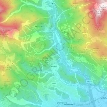
Name: Raveo topographic map, elevation, terrain.
Location: Raveo, Udine, Friuli – Venezia Giulia, 33029, Italy (46.41473 12.80544 46.47060 12.90564)
Average elevation: 766 m
Minimum elevation: 359 m
Maximum elevation: 1,736 m
Make a donation
Gear up for your next adventure:
As an Amazon Associate, this site earns from qualifying purchases at no extra cost to you.
Other topographic maps
Click on a map to view its topography, its elevation and its terrain.
Tribil Superiore / Gorenji Tarbij
Italy > Friuli – Venezia Giulia > Udine > Stregna
Average elevation: 500 m
Make a donation
Gear up for your next adventure:
As an Amazon Associate, this site earns from qualifying purchases at no extra cost to you.
Make a donation
Gear up for your next adventure:
As an Amazon Associate, this site earns from qualifying purchases at no extra cost to you.
Timau / Tischlbong
Italy > Friuli – Venezia Giulia > Udine > Paluzza / Paluce / Palutsch
Average elevation: 1,307 m
Sauris di Sopra / Plozn / Sauris Disore
Italy > Friuli – Venezia Giulia > Udine
Average elevation: 1,469 m
Make a donation
Gear up for your next adventure:
As an Amazon Associate, this site earns from qualifying purchases at no extra cost to you.