
Make a donation
Gear up for your next adventure:
As an Amazon Associate, this site earns from qualifying purchases at no extra cost to you.
Springfield topographic map
Click on the map to display elevation.
Make a donation
Gear up for your next adventure:
As an Amazon Associate, this site earns from qualifying purchases at no extra cost to you.
Springfield
Aside from its rivers, Springfield's second most prominent topographical feature is the city's 735-acre (297 ha) Forest Park. Forest Park lies in the southwestern corner of the city, surrounded by Springfield's attractive garden districts, Forest Park and Forest Park Heights, which feature over 600 Victorian Painted Lady mansions. Forest Park also borders Western Massachusetts' most affluent town, Longmeadow. Springfield shares borders with other well-heeled suburbs such as East Longmeadow, Wilbraham, Ludlow and the de-industrializing city of Chicopee. The small cities of Agawam and West Springfield lie less than a mile (1.6 km) from Springfield's Metro Center, across the Connecticut River.
Make a donation
Gear up for your next adventure:
As an Amazon Associate, this site earns from qualifying purchases at no extra cost to you.
About this map
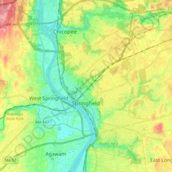
Name: Springfield topographic map, elevation, terrain.
Average elevation: 50 m
Minimum elevation: 8 m
Maximum elevation: 115 m
Make a donation
Gear up for your next adventure:
As an Amazon Associate, this site earns from qualifying purchases at no extra cost to you.