Geolocate

Bierhütte topographic map

Click on the map to display elevation.

About this map

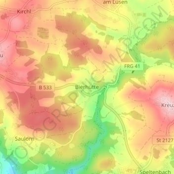
Name: Bierhütte topographic map, elevation, terrain.

Location: Bierhütte, Hohenau, Landkreis Freyung-Grafenau, Bavaria, 94545, Germany (48.82268 13.50425 48.86268 13.54425)

Average elevation: 716 m

Minimum elevation: 578 m

Maximum elevation: 821 m

Other topographic maps

Click on a map to view its topography, its elevation and its terrain.

Freyung

Germany > Bavaria > Landkreis Freyung-Grafenau > Freyung

Average elevation: 695 m

Zenting

Germany > Bavaria > Landkreis Freyung-Grafenau > Zenting

Average elevation: 550 m

Gear up for your next adventure:

🕯️Camping Lantern - Illuminates your entire campsite with high-efficiency LEDs
🦌Outdoor Trail Camera - Monitor wildlife activity near your favorite spots
🥾Hiking Leggings - Comfortable leggings for outdoor activities
🧊Insulated Water Bottle - Keeps drinks cold in summer and prevents freezing in winter
🥾Hiking Boots - Sturdy boots providing ankle support and traction on rugged trails

As an Amazon Associate, this site earns from qualifying purchases at no extra cost to you.