Geolocate

Hastings topographic map

Click on the map to display elevation.

About this map

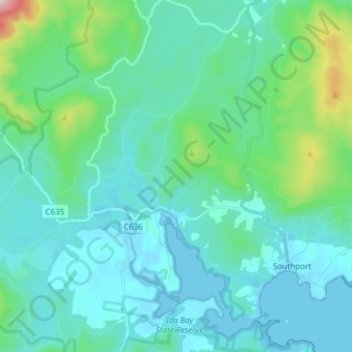
Name: Hastings topographic map, elevation, terrain.

Location: Hastings, Huon Valley, Tasmania, Australia (-43.43989 146.80737 -43.36578 146.95639)

Average elevation: 122 m

Minimum elevation: -7 m

Maximum elevation: 835 m

Gear up for your next adventure:

🦌Outdoor Trail Camera - Monitor wildlife activity near your favorite spots
🏃Hydration Running Vest - Carry water and maps close to your body for speed
🧥Thermal Layer - Insulating layer for cold outdoor conditions
🧥Softshell Hiking Jacket - The perfect balance of wind protection and breathability
🥾Hiking Gaiters - Protect legs and shoes from mud, snow, and debris

As an Amazon Associate, this site earns from qualifying purchases at no extra cost to you.