
Sterling topographic map
Click on the map to display elevation.
Sterling
According to the USGS, Sterling has an average elevation of 289 feet (88 m) above sea level. The original center of Sterling is located at 39°00'22.4"N 77°25'43.0"W. Sterling is part of the Chesapeake Bay watershed, and Greater Sterling borders the Potomac River.
About this map
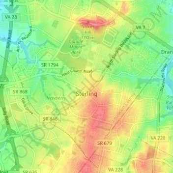
Name: Sterling topographic map, elevation, terrain.
Location: Sterling, Loudoun County, Virginia, 20164, United States (38.98265 -77.43496 39.02504 -77.37132)
Average elevation: 97 m
Minimum elevation: 67 m
Maximum elevation: 131 m
Other topographic maps
Click on a map to view its topography, its elevation and its terrain.
Lucketts Community Center
United States > Virginia > Loudoun County > Lucketts
Average elevation: 101 m