Geolocate

Bodafors topographic map

Click on the map to display elevation.

About this map

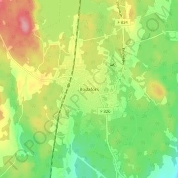
Name: Bodafors topographic map, elevation, terrain.

Location: Bodafors, Nässjö kommun, Jönköping County, 571 62, Sweden (57.48526 14.68338 57.52526 14.72338)

Average elevation: 283 m

Minimum elevation: 234 m

Maximum elevation: 346 m

Other topographic maps

Click on a map to view its topography, its elevation and its terrain.

Grand

Sweden > Jönköping County > Rörvik

Average elevation: 215 m

Gislaveds kommun

Sweden > Jönköping County

Average elevation: 178 m

Gear up for your next adventure:

🧴Bear Spray Holster - Quick-access carry for essential Canadian wilderness safety
🥾Mountain Trail Shoes - High-traction shoes for mountain trails
🚲Bike Repair Kit - Essential tools for on-trail mechanical issues
🧤Insulated Winter Gloves - Heavy-duty protection for sub-zero Canadian adventures
🕯️Camping Lantern - Illuminates your entire campsite with high-efficiency LEDs

As an Amazon Associate, this site earns from qualifying purchases at no extra cost to you.