Geolocate

Cardiff topographic map

Click on the map to display elevation.

About this map
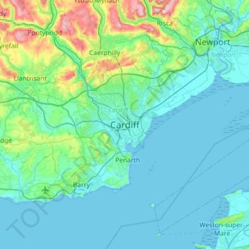
Name: Cardiff topographic map, elevation, terrain.

Location: Cardiff, Wales, CF10 2AF, United Kingdom (51.32165 -3.33919 51.64165 -3.01919)

Average elevation: 55 m

Minimum elevation: 0 m

Maximum elevation: 417 m

Other topographic maps

Click on a map to view its topography, its elevation and its terrain.
Dipping Pond

United Kingdom > Wales > Cardiff > Cardiff

Average elevation: 50 m

Gear up for your next adventure:

🔪Outdoor Multitool - Versatile tool for repairs and food prep in the wild
🥾Light Hiking Boots - Lightweight and comfortable boots for day hikes
🧦Hiking Liner Socks - Thin base layer to prevent friction and blisters
💡Portable Camping Lamp - Rechargeable lamp for campsite lighting
🛁Quick-Dry Microfiber Towel - Space-saving towel that dries rapidly on the move

As an Amazon Associate, this site earns from qualifying purchases at no extra cost to you.