Quindío topographic map
Click on the map to display elevation.
Quindío
With law 61 of 1985, the Colombian Congress adopted the Quindío wax palm tree, Ceroxylon quindiuense, a local endangered species adapted to high altitudes, as the National Tree. As ratified on September 16, 1985, by the then president of Colombia, Belisario Betancur, the law states: "The species commonly known as the Quindío wax palm tree, scientific name Ceroxylon quindiuense, is declared the national tree and symbol of our fatherland. The national government is empowered to buy as much land as needed to create wildlife sanctuaries with the purpose of preserving this national symbol and its natural environment. It is forbidden to cut down the Quindío wax palm tree. The punishment for doing so shall be a fine and a term in jail"."
About this map
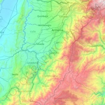
Name: Quindío topographic map, elevation, terrain.
Location: Quindío, RAP Eje Cafetero, Colombia (4.07521 -75.89580 4.72138 -75.38269)
Average elevation: 2,057 m
Minimum elevation: 899 m
Maximum elevation: 4,743 m
Other topographic maps
Click on a map to view its topography, its elevation and its terrain.