
Thank you for supporting this site ❤️
Make a donation
Make a donation
Gear up for your next adventure:
As an Amazon Associate, this site earns from qualifying purchases at no extra cost to you.
Jumet topographic map
Click on the map to display elevation.
Thank you for supporting this site ❤️
Make a donation
Make a donation
Gear up for your next adventure:
As an Amazon Associate, this site earns from qualifying purchases at no extra cost to you.
About this map
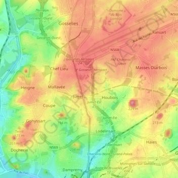
Name: Jumet topographic map, elevation, terrain.
Location: Jumet, Charleroi, Hainaut, Wallonia, 6040, Belgium (50.42717 4.39848 50.46147 4.48764)
Average elevation: 153 m
Minimum elevation: 100 m
Maximum elevation: 199 m
Thank you for supporting this site ❤️
Make a donation
Make a donation
Gear up for your next adventure:
As an Amazon Associate, this site earns from qualifying purchases at no extra cost to you.