
Freiberg topographic map
Click on the map to display elevation.
Freiberg
The town lies on the northern declivity of the Ore Mountains, with the majority of the borough west of the Eastern or Freiberger Mulde river. Parts of the town are nestled in the valleys of Münzbach and Goldbach streams. Its centre has an altitude of about 412 m above sea level (NHN) (at the railway station). Its lowest point is on Münzbach on the town boundary at 340 m above NHN; its highest point is on an old mining tip at 491 m above NHN. Freiberg lies within a region of old forest clearances, subsequently used by the mining industry which left its mark on the landscape. The town is surrounded to the north, southeast and southwest by woods, and in the other directions by fields and meadows. Since the beginning of the 21st century an urbanised area has gradually developed which is formed by the towns of Nossen, Roßwein, Großschirma, Freiberg and Brand-Erbisdorf. It currently has about 75,000 inhabitants.
About this map
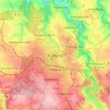
Name: Freiberg topographic map, elevation, terrain.
Location: Freiberg, Mittelsachsen, Saxony, 09599, Germany (50.87546 13.26608 50.95908 13.40051)
Average elevation: 405 m
Minimum elevation: 296 m
Maximum elevation: 491 m