Geolocate

Frohburg topographic map

Click on the map to display elevation.

About this map

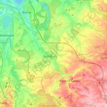
Name: Frohburg topographic map, elevation, terrain.

Location: Frohburg, Landkreis Leipzig, Saxony, Germany (50.97887 12.50114 51.14314 12.72251)

Average elevation: 188 m

Minimum elevation: 128 m

Maximum elevation: 278 m

Gear up for your next adventure:

💡Portable Camping Lamp - Rechargeable lamp for campsite lighting
🪑Ultralight Camping Stool - Compact seating for rest stops during long hikes
🧰Multitool Knife - Compact and versatile tool for outdoor use
🔪Outdoor Multitool - Versatile tool for repairs and food prep in the wild
🥾Trail Hiking Socks - Comfortable socks to prevent blisters and fatigue

As an Amazon Associate, this site earns from qualifying purchases at no extra cost to you.