
Make a donation
Gear up for your next adventure:
As an Amazon Associate, this site earns from qualifying purchases at no extra cost to you.
Matosinhos topographic map
Click on the map to display elevation.
Make a donation
Gear up for your next adventure:
As an Amazon Associate, this site earns from qualifying purchases at no extra cost to you.
Matosinhos
At the end of the Bronze Age, settlements expanded into castros, proto-urban agglomerations at high altitudes. These existed in the northwestern regions of the Iberian Peninsula and predominated until the 1st century. Remnants of castros remain throughout the municipality, the most notable being Castro of Monte Castelo in Guifões, by the estuary of the Leça river.
Make a donation
Gear up for your next adventure:
As an Amazon Associate, this site earns from qualifying purchases at no extra cost to you.
About this map
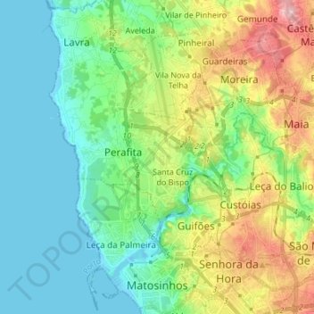
Name: Matosinhos topographic map, elevation, terrain.
Location: Matosinhos, Porto, Portugal (41.17149 -8.72916 41.27311 -8.59545)
Average elevation: 44 m
Minimum elevation: -3 m
Maximum elevation: 145 m
Make a donation
Gear up for your next adventure:
As an Amazon Associate, this site earns from qualifying purchases at no extra cost to you.
Other topographic maps
Click on a map to view its topography, its elevation and its terrain.