
Make a donation
Gear up for your next adventure:
As an Amazon Associate, this site earns from qualifying purchases at no extra cost to you.
New Haven County topographic map
Click on the map to display elevation.
Make a donation
Gear up for your next adventure:
As an Amazon Associate, this site earns from qualifying purchases at no extra cost to you.
New Haven County
The terrain is mostly flat near the coast, with low hills defining the rest of the area, rising significantly only in the north of the county. The highest elevation is close to the northernmost point in the county, found at two areas of approximately 1,050 feet (320 m) above sea level in the town of Wolcott. The lowest point is sea level.
Make a donation
Gear up for your next adventure:
As an Amazon Associate, this site earns from qualifying purchases at no extra cost to you.
About this map
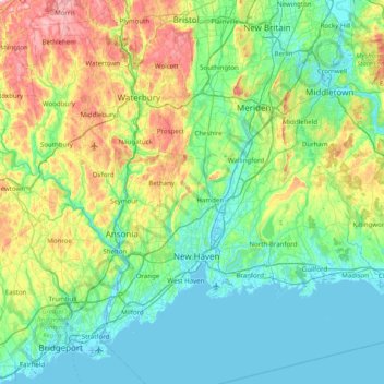
Name: New Haven County topographic map, elevation, terrain.
Average elevation: 89 m
Minimum elevation: -4 m
Maximum elevation: 385 m
Make a donation
Gear up for your next adventure:
As an Amazon Associate, this site earns from qualifying purchases at no extra cost to you.
Other topographic maps
Click on a map to view its topography, its elevation and its terrain.
Morningside
United States > Connecticut > South Central Connecticut Planning Region > Milford
Average elevation: 5 m
Big Indian
United States > Connecticut > South Central Connecticut Planning Region > Guilford
Average elevation: 41 m