Geolocate

Silver Plume topographic map

Click on the map to display elevation.

About this map

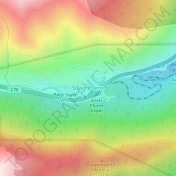
Name: Silver Plume topographic map, elevation, terrain.

Location: Silver Plume, Clear Creek County, Colorado, United States (39.69340 -105.73537 39.69875 -105.71901)

Average elevation: 3,106 m

Minimum elevation: 2,671 m

Maximum elevation: 3,657 m

Other topographic maps

Click on a map to view its topography, its elevation and its terrain.

Torreys Peak

United States > Colorado > Clear Creek County

The third trail starts at Loveland Pass about 4.5 miles (7.2 km) to the northwest. To reach Loveland Pass, follow I-70 west from Denver 55 miles (89 km) to where US Route 6 breaks off and heads south. Follow the meandering Route 6 approximately seven miles to the trailhead at Loveland Pass, at an elevation of…

Average elevation: 3,855 m

Grizzly Peak

United States > Colorado > Clear Creek County

Average elevation: 3,719 m

Grays Peak

United States > Colorado > Clear Creek County

Grays Peak is one of 53 fourteeners (mountains of over 14,000 feet (4,300 m) in elevation) in Colorado. Botanist Charles C. Parry made the first recorded ascent of the summit in 1861 and named the peak in honor of his botanist colleague Asa Gray. Gray did not see (and climb) the peak until 1872, eleven years…

Average elevation: 3,914 m

Gear up for your next adventure:

🛶Canoe Life Vest - Safety vest for water sports
🧥Packable Rain Jacket - Breathable waterproof layer for unpredictable weather
🧊Insulated Water Bottle - Keeps drinks cold in summer and prevents freezing in winter
🧶550 Survival Paracord - Versatile utility cord for emergency repairs and rigging
🔨Vehicle Emergency Tool - Safety tool for remote road trips to trailheads

As an Amazon Associate, this site earns from qualifying purchases at no extra cost to you.