Geolocate

Mount Wycheproof topographic map

Click on the map to display elevation.

About this map

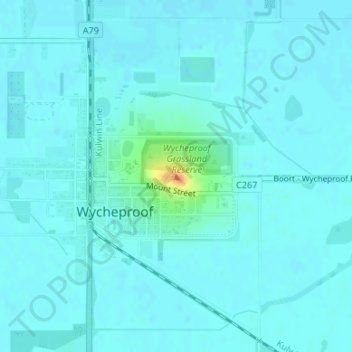
Name: Mount Wycheproof topographic map, elevation, terrain.

Location: Mount Wycheproof, Wycheproof, Shire of Buloke, Victoria, 3527, Australia (-36.07656 143.23371 -36.07646 143.23381)

Average elevation: 110 m

Minimum elevation: 105 m

Maximum elevation: 144 m

Gear up for your next adventure:

🔥Emergency Fire Starter - Reliable ignition source for all weather conditions
🕶️Polarized Sunglasses - Reduces glare from snow and water at high elevations
Bushcraft Tarp - Versatile emergency shelter or gear protection
🧤Rechargeable Heated Gloves - Extreme warmth for Canadian winter expeditions
🧊Portable Cooler - Keep food and drinks cold during outdoor adventures

As an Amazon Associate, this site earns from qualifying purchases at no extra cost to you.