Geolocate

Kingsland topographic map

Click on the map to display elevation.

About this map

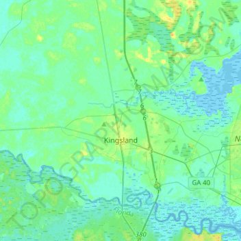
Name: Kingsland topographic map, elevation, terrain.

Location: Kingsland, Camden County, Georgia, United States (30.75502 -81.84942 30.87901 -81.59969)

Average elevation: 5 m

Minimum elevation: -3 m

Maximum elevation: 20 m

Other topographic maps

Click on a map to view its topography, its elevation and its terrain.

Gear up for your next adventure:

🥾Approach Shoes - Shoes designed for climbing approaches and rugged trails
🥽Outdoor Goggles - Protective eyewear for outdoor activities
🛏️Camping Sleeping Mat - Comfortable mats for sleeping outdoors
🧥Packable Rain Jacket - Breathable waterproof layer for unpredictable weather
Camping Groundsheet - Protect your tent from moisture and dirt

As an Amazon Associate, this site earns from qualifying purchases at no extra cost to you.