
Make a donation
Gear up for your next adventure:
As an Amazon Associate, this site earns from qualifying purchases at no extra cost to you.
Lobstädt topographic map
Click on the map to display elevation.
Make a donation
Gear up for your next adventure:
As an Amazon Associate, this site earns from qualifying purchases at no extra cost to you.
About this map
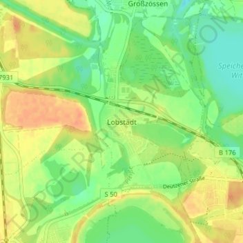
Name: Lobstädt topographic map, elevation, terrain.
Average elevation: 142 m
Minimum elevation: 124 m
Maximum elevation: 160 m
Make a donation
Gear up for your next adventure:
As an Amazon Associate, this site earns from qualifying purchases at no extra cost to you.
Other topographic maps
Click on a map to view its topography, its elevation and its terrain.
Pegau
Deutschland > Sachsen > Landkreis Leipzig
Das Rathaus liegt inmitten der Stadt und prägt das alte Stadtbild. Es wurde von 1559 bis 1561 von Paul Widemann und Hieronymus Lotter in den Formen der deutschen Renaissance erbaut. Auffällig ist die große Ähnlichkeit mit dem Leipziger Alten Rathaus (erbaut 1556/1557), an dessen Umbau Lotter und Wiedemann…
Average elevation: 133 m