Geolocate

Sukma topographic map

Click on the map to display elevation.

Sukma

It is located at 18°24′0″N 81°40′0″E / 18.40000°N 81.66667°E / 18.40000; 81.66667 at an elevation of 210 m above MSL.

Wikipedia (CC-BY-SA 3.0)

About this map

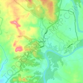
Name: Sukma topographic map, elevation, terrain.

Location: Sukma, Sukma Tahsil, Sukma District, Chhattisgarh, 494111, India (18.35322 81.61695 18.43322 81.69695)

Average elevation: 219 m

Minimum elevation: 180 m

Maximum elevation: 298 m

Gear up for your next adventure:

🗺️Topographic Maps - Detailed maps to explore trails, mountains, and wilderness areas
🦟Insect Repellent - Keep mosquitoes and black flies away in wooded areas
🔭Compact Monocular - One-handed bird watching and trail spotting
🧥Softshell Hiking Jacket - The perfect balance of wind protection and breathability
👟Trail Running Shoes - Agile footwear for fast-paced topographic exploration

As an Amazon Associate, this site earns from qualifying purchases at no extra cost to you.