Geolocate

Rome topographic map

Click on the map to display elevation.

About this map

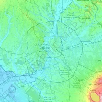
Name: Rome topographic map, elevation, terrain.

Location: Rome, Roma Capitale, Lazio, 00100, Italy (41.73332 12.32293 42.05332 12.64293)

Average elevation: 78 m

Minimum elevation: -2 m

Maximum elevation: 648 m

Other topographic maps

Click on a map to view its topography, its elevation and its terrain.

Villa Borghese Park

Italy > Lazio > Roma Capitale > Rome

Average elevation: 52 m

Gear up for your next adventure:

🛶Kayak Dry Bag - Waterproof storage for kayaking adventures
🛌Down Sleeping Bag - Superior warmth-to-weight ratio for cold nights
🔋Solar Power Bank - Keep your GPS and devices charged during long outdoor trips
🔪Outdoor Multitool - Versatile tool for repairs and food prep in the wild
🕶️Polarized Sunglasses - Reduces glare from snow and water at high elevations

As an Amazon Associate, this site earns from qualifying purchases at no extra cost to you.