
Éveux topographic map
Interactive map
Click on the map to display elevation.
About this map
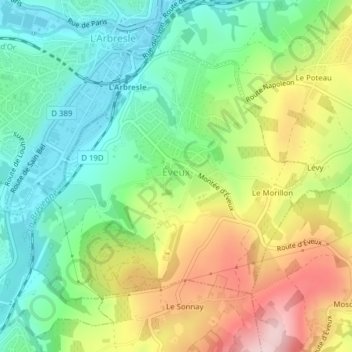
Name: Éveux topographic map, elevation, terrain.
Average elevation: 320 m
Minimum elevation: 221 m
Maximum elevation: 477 m
Other topographic maps
Click on a map to view its topography, its elevation and its terrain.
Grand Pré
France > Auvergne-Rhône-Alpes > Rhône > Fleurie
Grand Pré, Fleurie, Villefranche-sur-Saône, Rhône, Auvergne-Rhône-Alpes, Metropolitan France, 69820, France
Average elevation: 318 m
Chiroubles
France > Auvergne-Rhône-Alpes > Rhône
Chiroubles, Villefranche-sur-Saône, Rhône, Auvergne-Rhône-Alpes, Metropolitan France, 69115, France
Average elevation: 406 m
Alix
France > Auvergne-Rhône-Alpes > Rhône
Alix, Villefranche-sur-Saône, Rhône, Auvergne-Rhône-Alpes, Metropolitan France, 69380, France
Average elevation: 321 m