Geolocate

Gallipoli topographic map

Click on the map to display elevation.

About this map

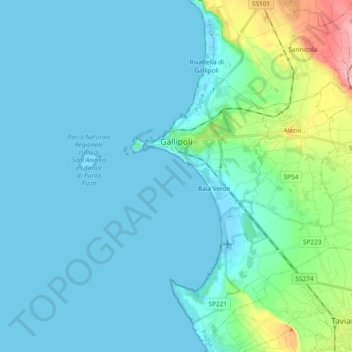
Name: Gallipoli topographic map, elevation, terrain.

Location: Gallipoli, Lecce, Apulia, 73014, Italy (39.97076 17.94482 40.11415 18.07814)

Average elevation: 18 m

Minimum elevation: -2 m

Maximum elevation: 129 m

Other topographic maps

Click on a map to view its topography, its elevation and its terrain.

Santa Maria al Bagno

Italy > Apulia > Lecce > Nardò

Average elevation: 32 m

Torre Chianca

Italy > Apulia > Lecce > Lecce

Average elevation: 2 m

Gear up for your next adventure:

🔋Lithium AA Batteries - Long-lasting power that performs in extreme cold
🧼Biodegradable Camp Soap - Environmentally friendly cleaning for gear and body
🧊Insulated Water Bottle - Keeps drinks cold in summer and prevents freezing in winter
🛌Down Sleeping Bag - Superior warmth-to-weight ratio for cold nights
🥽Outdoor Goggles - Protective eyewear for outdoor activities

As an Amazon Associate, this site earns from qualifying purchases at no extra cost to you.