Geolocate

Eichstätt topographic map

Click on the map to display elevation.

About this map

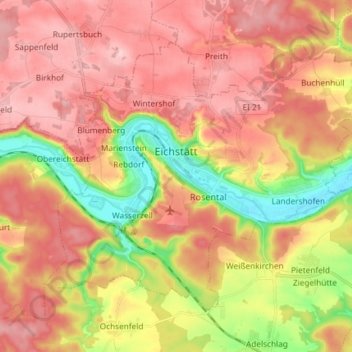
Name: Eichstätt topographic map, elevation, terrain.

Location: Eichstätt, Landkreis Eichstätt, Bavaria, 85072, Germany (48.84956 11.12862 48.92340 11.27564)

Average elevation: 490 m

Minimum elevation: 382 m

Maximum elevation: 566 m

Other topographic maps

Click on a map to view its topography, its elevation and its terrain.

Hard

Germany > Bavaria > Landkreis Eichstätt > Hard

Average elevation: 472 m

Gear up for your next adventure:

💡LED Headlamp - Hands-free illumination for night hiking and camping
🥾Durable Hiking Shoes - Long-lasting shoes for frequent hiking
🪑Ultralight Camping Stool - Compact seating for rest stops during long hikes
🥾Trekking Boots - Durable boots for long-distance trekking
🐕Hiking Dog Pack - Let your canine companion carry their own water and food

As an Amazon Associate, this site earns from qualifying purchases at no extra cost to you.