Geolocate

Neubrunn topographic map

Click on the map to display elevation.

About this map
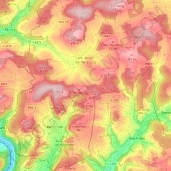
Name: Neubrunn topographic map, elevation, terrain.

Location: Neubrunn, Landkreis Würzburg, Bavaria, 97277, Germany (49.68710 9.62550 49.75411 9.71625)

Average elevation: 306 m

Minimum elevation: 165 m

Maximum elevation: 386 m

Other topographic maps

Click on a map to view its topography, its elevation and its terrain.

Dipbach

Germany > Bavaria > Landkreis Würzburg

Average elevation: 282 m

Obereisenheim

Germany > Bavaria > Landkreis Würzburg

Average elevation: 245 m

Gear up for your next adventure:

🛌Insulated Sleeping Pad - Critical thermal barrier between you and the cold ground
🩹Compact First Aid Kit - Pre-packed essentials for common trail injuries
🔦UV Flashlight - Detect minerals or specific insects in the dark
🥘Camping Cookware Set - Compact nesting pots and pans for trail cooking
🥤Collapsible Travel Cup - Saves space and weight in your mess kit

As an Amazon Associate, this site earns from qualifying purchases at no extra cost to you.