
Make a donation
Gear up for your next adventure:
As an Amazon Associate, this site earns from qualifying purchases at no extra cost to you.
Olpe topographic map
Click on the map to display elevation.
Make a donation
Gear up for your next adventure:
As an Amazon Associate, this site earns from qualifying purchases at no extra cost to you.
About this map
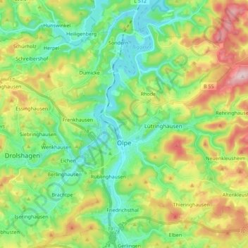
Name: Olpe topographic map, elevation, terrain.
Location: Olpe, Kreis Olpe, North Rhine-Westphalia, 57462, Germany (50.98689 7.80408 51.08780 7.97420)
Average elevation: 400 m
Minimum elevation: 306 m
Maximum elevation: 581 m
Make a donation
Gear up for your next adventure:
As an Amazon Associate, this site earns from qualifying purchases at no extra cost to you.
Other topographic maps
Click on a map to view its topography, its elevation and its terrain.
Altfinnentrop
Germany > North Rhine-Westphalia > Kreis Olpe > Finnentrop > Heggen
Average elevation: 316 m
Make a donation
Gear up for your next adventure:
As an Amazon Associate, this site earns from qualifying purchases at no extra cost to you.
Rüblinghausen
Germany > North Rhine-Westphalia > Kreis Olpe > Olpe > Rüblinghausen
Average elevation: 371 m