Geolocate

Rosemère topographic map

Click on the map to display elevation.

About this map

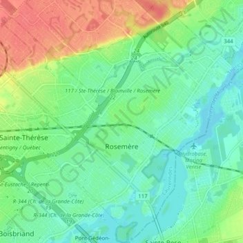
Name: Rosemère topographic map, elevation, terrain.

Location: Rosemère, Thérèse-De Blainville, Laurentides, Quebec, Canada (45.61092 -73.82855 45.66467 -73.76793)

Average elevation: 37 m

Minimum elevation: 17 m

Maximum elevation: 75 m

Thérèse-De Blainville trails, hiking, mountain biking, running and outdoor activities

Gear up for your next adventure:

🕶️Polarized Sunglasses - Reduces glare from snow and water at high elevations
💧Reusable Water Bottle - Durable water bottles for hydration on trails
🕯️Camping Lantern - Illuminates your entire campsite with high-efficiency LEDs
🥾Trekking Poles - Adjustable trekking poles to reduce knee stress and improve stability
👟Sport Hiking Sandals - Breathable footwear for water crossings and camp rest

As an Amazon Associate, this site earns from qualifying purchases at no extra cost to you.