
Thank you for supporting this site ❤️
Make a donation
Make a donation
Gear up for your next adventure:
As an Amazon Associate, this site earns from qualifying purchases at no extra cost to you.
Tebessa topographic map
Click on the map to display elevation.
Thank you for supporting this site ❤️
Make a donation
Make a donation
Gear up for your next adventure:
As an Amazon Associate, this site earns from qualifying purchases at no extra cost to you.
About this map
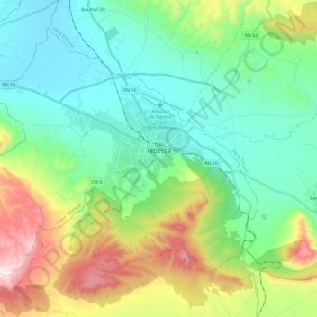
Name: Tebessa topographic map, elevation, terrain.
Location: Tebessa, Tébessa District, Tébessa, 12000, Algeria (35.31940 7.95945 35.47764 8.19517)
Average elevation: 1,030 m
Minimum elevation: 770 m
Maximum elevation: 1,700 m
Thank you for supporting this site ❤️
Make a donation
Make a donation
Gear up for your next adventure:
As an Amazon Associate, this site earns from qualifying purchases at no extra cost to you.