Geolocate

Manta topographic map

Click on the map to display elevation.

About this map

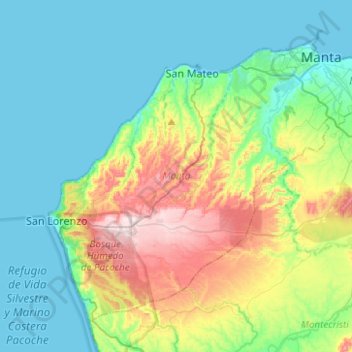
Name: Manta topographic map, elevation, terrain.

Location: Manta, Manabí, Ecuador (-1.13569 -80.91277 -0.92893 -80.66398)

Average elevation: 102 m

Minimum elevation: -1 m

Maximum elevation: 387 m

Gear up for your next adventure:

💧Filtered Water Bottle - Safe drinking water on the go
🥤Collapsible Travel Cup - Saves space and weight in your mess kit
🛰️Satellite Messenger - Emergency communication for areas with no cell service
🥾Trekking Poles - Adjustable trekking poles to reduce knee stress and improve stability
🥾Trail Running Boots - Durable shoes designed for trail running

As an Amazon Associate, this site earns from qualifying purchases at no extra cost to you.