Geolocate

Andria topographic map

Click on the map to display elevation.

About this map

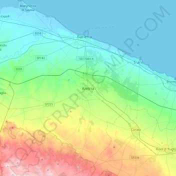
Name: Andria topographic map, elevation, terrain.

Location: Andria, Barletta-Andria-Trani, Apulia, 76123, Italy (41.06765 16.13543 41.38765 16.45543)

Average elevation: 152 m

Minimum elevation: -3 m

Maximum elevation: 613 m

Gear up for your next adventure:

🧴Waterproofing Spray - Restore the DWR coating on jackets and tents
👟Trail Running Shoes - Agile footwear for fast-paced topographic exploration
🎒Fully Waterproof Backpack - Total protection for photography gear and electronics
🧶550 Survival Paracord - Versatile utility cord for emergency repairs and rigging
🚲Handlebar Phone Mount - View topographic-map.com live while cycling

As an Amazon Associate, this site earns from qualifying purchases at no extra cost to you.