
Make a donation
Gear up for your next adventure:
As an Amazon Associate, this site earns from qualifying purchases at no extra cost to you.
New Bedford topographic map
Click on the map to display elevation.
Make a donation
Gear up for your next adventure:
As an Amazon Associate, this site earns from qualifying purchases at no extra cost to you.
New Bedford
New Bedford is located at 41°39′06″N 70°56′01″W / 41.651803°N 70.933705°W / 41.651803; -70.933705 (41.651803, −70.933705). According to the United States Census Bureau, the city has a total area of 24.1 square miles (62.5 km2). Of the total area, 20.0 square miles (51.8 km2) is land, and 4.1 square miles (10.7 km2), or 17.13%, is water. New Bedford is a coastal city, a seaport, bordered on the west by Dartmouth, on the north by Freetown, on the east by Acushnet and Fairhaven, and on the south by Buzzards Bay. From New Bedford's northern border with Freetown to the Buzzards Bay coast at Clark's Point the distance is approximately 14 miles (23 km). Across New Bedford east to west is a distance of about 2 miles (3.2 km). The highest point in the city is an unnamed hill crossed by Interstate 195 and Hathaway Road west of downtown, with an elevation greater than 180 feet (55 m) above sea level.
Make a donation
Gear up for your next adventure:
As an Amazon Associate, this site earns from qualifying purchases at no extra cost to you.
About this map
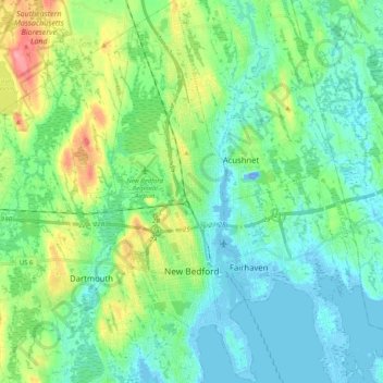
Name: New Bedford topographic map, elevation, terrain.
Location: New Bedford, Bristol County, Massachusetts, United States (41.59139 -70.97751 41.74467 -70.89939)
Average elevation: 21 m
Minimum elevation: -19 m
Maximum elevation: 80 m
Make a donation
Gear up for your next adventure:
As an Amazon Associate, this site earns from qualifying purchases at no extra cost to you.
Other topographic maps
Click on a map to view its topography, its elevation and its terrain.
Make a donation
Gear up for your next adventure:
As an Amazon Associate, this site earns from qualifying purchases at no extra cost to you.