Geolocate

Loreto topographic map

Click on the map to display elevation.

About this map

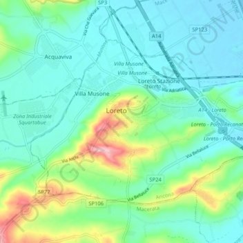
Name: Loreto topographic map, elevation, terrain.

Location: Loreto, Ancona, 60025, Italy (43.41729 13.57894 43.45632 13.65862)

Average elevation: 44 m

Minimum elevation: -2 m

Maximum elevation: 194 m

Other topographic maps

Click on a map to view its topography, its elevation and its terrain.

Bassano

Italy > Ancona > Fabriano > Argignano

Average elevation: 354 m

Gear up for your next adventure:

🔥Emergency Fire Starter - Reliable ignition source for all weather conditions
🧥Softshell Hiking Jacket - The perfect balance of wind protection and breathability
🧊Insulated Water Bottle - Keeps drinks cold in summer and prevents freezing in winter
🐕Hiking Dog Pack - Let your canine companion carry their own water and food
🧥Thermal Fleece Jacket - Versatile insulation for changing mountain temperatures

As an Amazon Associate, this site earns from qualifying purchases at no extra cost to you.