Geolocate

Lake Wales topographic map

Click on the map to display elevation.

About this map

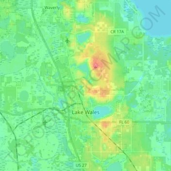
Name: Lake Wales topographic map, elevation, terrain.

Location: Lake Wales, Polk County, Florida, United States (27.85794 -81.66066 27.98429 -81.53120)

Average elevation: 41 m

Minimum elevation: 21 m

Maximum elevation: 97 m

Other topographic maps

Click on a map to view its topography, its elevation and its terrain.

Iron Mountain

United States > Florida > Polk County

Average elevation: 60 m

Bok Tower

United States > Florida > Polk County

Average elevation: 60 m

Gear up for your next adventure:

🥾Mountain Hiking Shoes - Shoes with superior grip for mountainous terrain
🧼Travel Hand Sanitizer - Keep hands clean when water is scarce
🧤Rechargeable Heated Gloves - Extreme warmth for Canadian winter expeditions
🥾Mountain Hiking Boots - High-traction boots for rocky terrain
💡Portable Camping Lamp - Rechargeable lamp for campsite lighting

As an Amazon Associate, this site earns from qualifying purchases at no extra cost to you.