Geolocate

Borrowdale topographic map

Click on the map to display elevation.

About this map

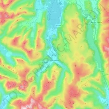
Name: Borrowdale topographic map, elevation, terrain.

Location: Borrowdale, Cumberland, England, United Kingdom (54.45410 -3.21932 54.59275 -3.08723)

Average elevation: 384 m

Minimum elevation: 62 m

Maximum elevation: 969 m

Other topographic maps

Click on a map to view its topography, its elevation and its terrain.

Cold Fell

United Kingdom > England > Cumberland > Castle Carrock

Average elevation: 517 m

Ennerdale Bridge

United Kingdom > England > Cumberland

Average elevation: 187 m

Harker

United Kingdom > England > Cumberland

Average elevation: 24 m

Carlisle

United Kingdom > England > Cumberland

Average elevation: 31 m

Gear up for your next adventure:

🔋Solar Power Bank - Keep your GPS and devices charged during long outdoor trips
🧥Thermal Layer - Insulating layer for cold outdoor conditions
👟Trail Running Shoes - Agile footwear for fast-paced topographic exploration
🧤Thermal Hiking Gloves - Grip-enhanced gloves for cold-weather altitude trekking
🪑Insulated Seat Pad - Protect your seat from cold rocks and wet logs

As an Amazon Associate, this site earns from qualifying purchases at no extra cost to you.