
Thank you for supporting this site ❤️
Make a donation
Make a donation
Gear up for your next adventure:
As an Amazon Associate, this site earns from qualifying purchases at no extra cost to you.
Plymouth topographic map
Click on the map to display elevation.
Thank you for supporting this site ❤️
Make a donation
Make a donation
Gear up for your next adventure:
As an Amazon Associate, this site earns from qualifying purchases at no extra cost to you.
About this map
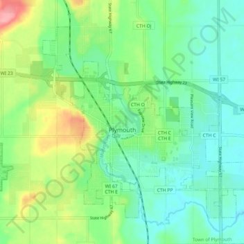
Name: Plymouth topographic map, elevation, terrain.
Location: Plymouth, Sheboygan County, Wisconsin, 53073, United States (43.72525 -88.00632 43.77588 -87.91673)
Average elevation: 265 m
Minimum elevation: 233 m
Maximum elevation: 340 m
Thank you for supporting this site ❤️
Make a donation
Make a donation
Gear up for your next adventure:
As an Amazon Associate, this site earns from qualifying purchases at no extra cost to you.
Other topographic maps
Click on a map to view its topography, its elevation and its terrain.
Sheboygan Marsh 2 WP 319 Dam
United States > Wisconsin > Sheboygan County > Town of Russell
Average elevation: 284 m