Geolocate

Daun topographic map

Click on the map to display elevation.

About this map
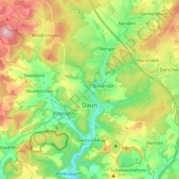
Name: Daun topographic map, elevation, terrain.

Location: Daun, Landkreis Vulkaneifel, Rhineland-Palatinate, 54550, Germany (50.16101 6.74411 50.24611 6.87554)

Average elevation: 485 m

Minimum elevation: 350 m

Maximum elevation: 696 m

Other topographic maps

Click on a map to view its topography, its elevation and its terrain.
Gear up for your next adventure:

🧦Crew Hiking Socks - Comfortable socks for long-distance hikes
🥫Freeze-Dried Meals - Lightweight, high-calorie nutrition for multi-day treks
🔪Outdoor Multitool - Versatile tool for repairs and food prep in the wild
🥾All-Terrain Hiking Boots - Versatile boots for varied hiking conditions
🧼Travel Hand Sanitizer - Keep hands clean when water is scarce

As an Amazon Associate, this site earns from qualifying purchases at no extra cost to you.