
Make a donation
Gear up for your next adventure:
As an Amazon Associate, this site earns from qualifying purchases at no extra cost to you.
Steinheim am Albuch topographic map
Click on the map to display elevation.
Make a donation
Gear up for your next adventure:
As an Amazon Associate, this site earns from qualifying purchases at no extra cost to you.
About this map
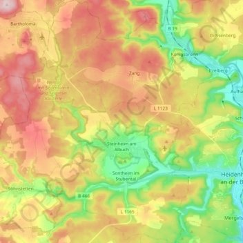
Name: Steinheim am Albuch topographic map, elevation, terrain.
Average elevation: 614 m
Minimum elevation: 480 m
Maximum elevation: 761 m
Make a donation
Gear up for your next adventure:
As an Amazon Associate, this site earns from qualifying purchases at no extra cost to you.
Other topographic maps
Click on a map to view its topography, its elevation and its terrain.
Nördlinger Stein
Germany > Baden-Württemberg > Landkreis Heidenheim > Königsbronn > Zahnberg
Average elevation: 586 m
Schnaitheim
Germany > Baden-Württemberg > Landkreis Heidenheim > Heidenheim an der Brenz
Average elevation: 551 m
Schnepfenstand
Germany > Baden-Württemberg > Landkreis Heidenheim > Herbrechtingen
Average elevation: 574 m
Make a donation
Gear up for your next adventure:
As an Amazon Associate, this site earns from qualifying purchases at no extra cost to you.
Hitzingsweiler
Germany > Baden-Württemberg > Landkreis Heidenheim > Königsbronn
Average elevation: 639 m