Geolocate

Franklin topographic map

Click on the map to display elevation.

Franklin

Franklin is located at 35°10′52″N 83°22′54″W / 35.18111°N 83.38167°W / 35.18111; -83.38167 (35.181144, -83.381685). The elevation of Franklin is 2119 ft.

About this map

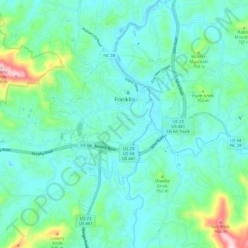
Name: Franklin topographic map, elevation, terrain.

Location: Franklin, Macon County, North Carolina, 28734, United States (35.13238 -83.43950 35.21556 -83.35178)

Average elevation: 675 m

Minimum elevation: 598 m

Maximum elevation: 1,013 m

Gear up for your next adventure:

🔋Lithium AA Batteries - Long-lasting power that performs in extreme cold
💧Collapsible Water Bottle - Space-saving water bottle for outdoor activities
🛶Waterproof Dry Bags - Keep electronics and clothes dry during river crossings
Lightweight Backpacking Tent - Compact tent for efficient hiking trips
🚲Handlebar Phone Mount - View topographic-map.com live while cycling

As an Amazon Associate, this site earns from qualifying purchases at no extra cost to you.