Geolocate

Barrow Gurney topographic map

Click on the map to display elevation.

About this map

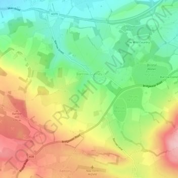
Name: Barrow Gurney topographic map, elevation, terrain.

Location: Barrow Gurney, North Somerset, England, United Kingdom (51.39140 -2.70805 51.42071 -2.65394)

Average elevation: 115 m

Minimum elevation: 33 m

Maximum elevation: 218 m

Gear up for your next adventure:

🦟Insect Repellent - Keep mosquitoes and black flies away in wooded areas
🔥Emergency Fire Starter - Reliable ignition source for all weather conditions
Family Camping Tent - Spacious tent suitable for family camping trips
🧥Insulated Jacket - Keep warm in cold outdoor conditions
🧰Survival Kit - Essential gear for emergencies in the wilderness

As an Amazon Associate, this site earns from qualifying purchases at no extra cost to you.