
Make a donation
Gear up for your next adventure:
As an Amazon Associate, this site earns from qualifying purchases at no extra cost to you.
Teixeira de Freitas topographic map
Click on the map to display elevation.
Make a donation
Gear up for your next adventure:
As an Amazon Associate, this site earns from qualifying purchases at no extra cost to you.
About this map
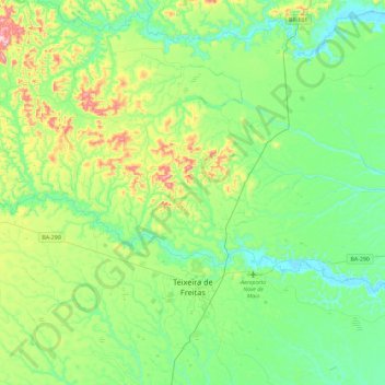
Name: Teixeira de Freitas topographic map, elevation, terrain.
Average elevation: 116 m
Minimum elevation: 3 m
Maximum elevation: 444 m
Make a donation
Gear up for your next adventure:
As an Amazon Associate, this site earns from qualifying purchases at no extra cost to you.
Other topographic maps
Click on a map to view its topography, its elevation and its terrain.
Chapada Diamantina
The Chapada Diamantina lies at the center of Bahia State and forms the northern part of the Espinhaço Mountain Range. The region is approximately 38,000 km2 (15,000 sq mi) in area and encompasses 58 municipalities. Technically, this region is considered a part of the caatinga biome, and contains some of its…
Average elevation: 1,390 m
Costa do Sauípe
Brazil > Bahia > Região Metropolitana de Salvador > Mata de São João
Average elevation: 10 m
Make a donation
Gear up for your next adventure:
As an Amazon Associate, this site earns from qualifying purchases at no extra cost to you.
Chapada Diamantina
The Chapada Diamantina lies at the center of Bahia State and forms the northern part of the Espinhaço Mountain Range. The region is approximately 38,000 km2 (15,000 sq mi) in area and encompasses 58 municipalities. Technically, this region is considered a part of the caatinga biome, and contains some of its…
Average elevation: 1,390 m
Praia do Forte
Brazil > Bahia > Região Metropolitana de Salvador > Mata de São João
Average elevation: 5 m
Make a donation
Gear up for your next adventure:
As an Amazon Associate, this site earns from qualifying purchases at no extra cost to you.
Chapada Diamantina
The Chapada Diamantina lies at the center of Bahia State and forms the northern part of the Espinhaço Mountain Range. The region is approximately 38,000 km2 (15,000 sq mi) in area and encompasses 58 municipalities. Technically, this region is considered a part of the caatinga biome, and contains some of its…
Average elevation: 1,390 m
Make a donation
Gear up for your next adventure:
As an Amazon Associate, this site earns from qualifying purchases at no extra cost to you.
Serra do Cipó
Brazil > Bahia > Região Metropolitana de Feira de Santana > Ipecaetá
Average elevation: 254 m
Campos
Brazil > Bahia > Região Administrativa Integrada de Desenvolvimento do Polo Petrolina e Juazeiro > Juazeiro
Average elevation: 387 m
Make a donation
Gear up for your next adventure:
As an Amazon Associate, this site earns from qualifying purchases at no extra cost to you.
Make a donation
Gear up for your next adventure:
As an Amazon Associate, this site earns from qualifying purchases at no extra cost to you.