
Make a donation
Gear up for your next adventure:
As an Amazon Associate, this site earns from qualifying purchases at no extra cost to you.
Mercersburg topographic map
Click on the map to display elevation.
Make a donation
Gear up for your next adventure:
As an Amazon Associate, this site earns from qualifying purchases at no extra cost to you.
About this map
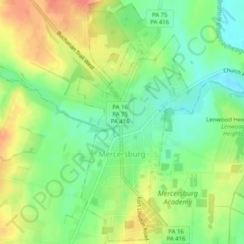
Name: Mercersburg topographic map, elevation, terrain.
Location: Mercersburg, Franklin County, Pennsylvania, United States (39.81853 -77.91020 39.84491 -77.89419)
Average elevation: 181 m
Minimum elevation: 154 m
Maximum elevation: 214 m
Make a donation
Gear up for your next adventure:
As an Amazon Associate, this site earns from qualifying purchases at no extra cost to you.
Other topographic maps
Click on a map to view its topography, its elevation and its terrain.
Stoufferstown
United States > Pennsylvania > Franklin County > Guilford Township
Average elevation: 208 m
Blue Ridge Summit
United States > Pennsylvania > Franklin County > Washington Township
Pennsylvania Route 16 passes through Blue Ridge Summit, leading east down the mountain to Emmitsburg, Maryland, and west downhill to Waynesboro. The highway elevation at Blue Ridge Summit is 1,330 feet (410 m), compared to elevations of 500 and 700 feet (150 and 210 m) east and west of the mountain,…
Average elevation: 400 m
Caledonia State Park
United States > Pennsylvania > Franklin County > Greene Township
Average elevation: 367 m
Make a donation
Gear up for your next adventure:
As an Amazon Associate, this site earns from qualifying purchases at no extra cost to you.
Green Village
United States > Pennsylvania > Franklin County > Greene Township
Average elevation: 207 m
Make a donation
Gear up for your next adventure:
As an Amazon Associate, this site earns from qualifying purchases at no extra cost to you.
Metal
United States > Pennsylvania > Franklin County > Metal Township > Metal
Average elevation: 304 m