Geolocate

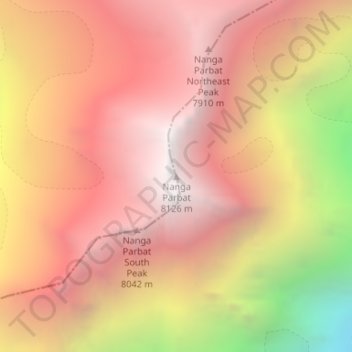
Nanga Parbat topographic map

Click on the map to display elevation.

Nanga Parbat

To the south, Nanga Parbat has what is often referred to as the highest mountain face in the world: the Rupal Face rises 4,600 m (15,090 ft) above its base. To the north, the complex, somewhat more gently-sloped Rakhiot Flank rises 7,000 m (23,000 ft) from the Indus River valley to the summit in just 25 km (16 mi), one of the ten greatest elevation gains in such a short distance on Earth.

Wikipedia (CC-BY-SA 3.0)

About this map

Name: Nanga Parbat topographic map, elevation, terrain.

Location: Nanga Parbat, Shounter Tehsil, Astore District, Diamer-Astore Division, Gilgit-Baltistan, Pakistan (35.23841 74.58949 35.23851 74.58959)

Average elevation: 7,086 m

Minimum elevation: 5,181 m

Maximum elevation: 8,104 m

Gear up for your next adventure:

🧤Thermal Hiking Gloves - Grip-enhanced gloves for cold-weather altitude trekking
🧤Rechargeable Heated Gloves - Extreme warmth for Canadian winter expeditions
🔋Solar Power Bank - Keep your GPS and devices charged during long outdoor trips
💡LED Camping Lantern - Illuminate your campsite with long-lasting lanterns
🧰Emergency Multi-Tool - Compact multi-tool for outdoor survival

As an Amazon Associate, this site earns from qualifying purchases at no extra cost to you.