Geolocate

Fort Payne topographic map

Click on the map to display elevation.

About this map

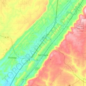
Name: Fort Payne topographic map, elevation, terrain.

Location: Fort Payne, DeKalb County, Alabama, United States (34.37007 -85.78068 34.53943 -85.60399)

Average elevation: 369 m

Minimum elevation: 220 m

Maximum elevation: 556 m

Other topographic maps

Click on a map to view its topography, its elevation and its terrain.

Dawson

United States > Alabama > DeKalb County

Average elevation: 307 m

Riverdale

United States > Alabama > DeKalb County > Mentone

Average elevation: 505 m

Dog Town

United States > Alabama > DeKalb County

Average elevation: 408 m

Mount Brandon

United States > Alabama > DeKalb County

Average elevation: 419 m

Wooten Hill

United States > Alabama > DeKalb County

Average elevation: 387 m

Gear up for your next adventure:

🥾Durable Hiking Shoes - Long-lasting shoes for frequent hiking
🧭GPS Handheld Device - Reliable GPS navigation for outdoor adventures
🧳Compression Sacks - Maximize space in your backpack by shrinking gear
Camping Tent - Weather-resistant tents suitable for 2 to 6 people
🥾Lightweight Hiking Boots - Boots for comfort and mobility on long hikes

As an Amazon Associate, this site earns from qualifying purchases at no extra cost to you.