
Make a donation
Gear up for your next adventure:
As an Amazon Associate, this site earns from qualifying purchases at no extra cost to you.
Finnentrop topographic map
Click on the map to display elevation.
Make a donation
Gear up for your next adventure:
As an Amazon Associate, this site earns from qualifying purchases at no extra cost to you.
About this map
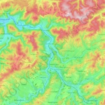
Name: Finnentrop topographic map, elevation, terrain.
Location: Finnentrop, Kreis Olpe, North Rhine-Westphalia, 57413, Germany (51.12875 7.89813 51.24831 8.12188)
Average elevation: 380 m
Minimum elevation: 202 m
Maximum elevation: 649 m
Make a donation
Gear up for your next adventure:
As an Amazon Associate, this site earns from qualifying purchases at no extra cost to you.
Other topographic maps
Click on a map to view its topography, its elevation and its terrain.
Altfinnentrop
Germany > North Rhine-Westphalia > Kreis Olpe > Finnentrop > Heggen
Average elevation: 316 m
Make a donation
Gear up for your next adventure:
As an Amazon Associate, this site earns from qualifying purchases at no extra cost to you.
Rüblinghausen
Germany > North Rhine-Westphalia > Kreis Olpe > Olpe > Rüblinghausen
Average elevation: 371 m