
Thank you for supporting this site ❤️
Make a donation
Make a donation
Gear up for your next adventure:
As an Amazon Associate, this site earns from qualifying purchases at no extra cost to you.
Liberec topographic map
Click on the map to display elevation.
Thank you for supporting this site ❤️
Make a donation
Make a donation
Gear up for your next adventure:
As an Amazon Associate, this site earns from qualifying purchases at no extra cost to you.
About this map
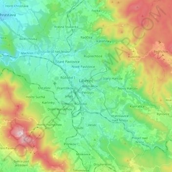
Name: Liberec topographic map, elevation, terrain.
Location: Liberec, okres Liberec, Liberecký kraj, Northeast, Czechia (50.70798 14.95297 50.82434 15.14688)
Average elevation: 510 m
Minimum elevation: 292 m
Maximum elevation: 996 m
Thank you for supporting this site ❤️
Make a donation
Make a donation
Gear up for your next adventure:
As an Amazon Associate, this site earns from qualifying purchases at no extra cost to you.