
Make a donation
Gear up for your next adventure:
As an Amazon Associate, this site earns from qualifying purchases at no extra cost to you.
West Windsor topographic map
Click on the map to display elevation.
Make a donation
Gear up for your next adventure:
As an Amazon Associate, this site earns from qualifying purchases at no extra cost to you.
West Windsor
The unincorporated village of Brownsville is one of the few urban areas in the town and sits at the northwestern base of Mount Ascutney (elevation 3143 ft.).[5]
Make a donation
Gear up for your next adventure:
As an Amazon Associate, this site earns from qualifying purchases at no extra cost to you.
About this map
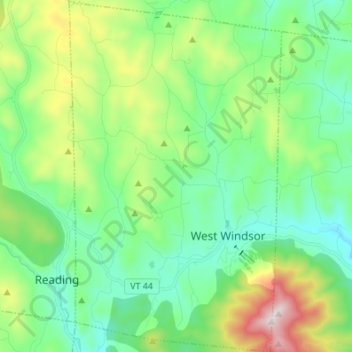
Name: West Windsor topographic map, elevation, terrain.
Location: West Windsor, Windsor County, Vermont, 05037, United States (43.43519 -72.53283 43.53387 -72.45051)
Average elevation: 366 m
Minimum elevation: 147 m
Maximum elevation: 945 m
Make a donation
Gear up for your next adventure:
As an Amazon Associate, this site earns from qualifying purchases at no extra cost to you.