Geolocate

Puri topographic map

Click on the map to display elevation.

About this map

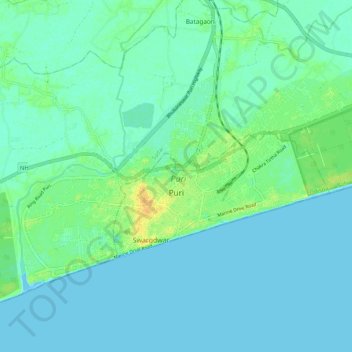
Name: Puri topographic map, elevation, terrain.

Location: Puri, Puri (M), Puri, Odisha, 752001, India (19.78159 85.77905 19.84288 85.88326)

Average elevation: 6 m

Minimum elevation: -1 m

Maximum elevation: 25 m

Gear up for your next adventure:

🧢Sun Protection Cap - Breathable cap to protect from sun exposure
🧶550 Survival Paracord - Versatile utility cord for emergency repairs and rigging
🥾Hiking Shorts - Breathable shorts suitable for summer hikes
🧦Outdoor Socks - Durable socks designed for hiking and outdoor sports
🥾Hiking Leggings - Comfortable leggings for outdoor activities

As an Amazon Associate, this site earns from qualifying purchases at no extra cost to you.