Geolocate

Ames topographic map

Click on the map to display elevation.

About this map

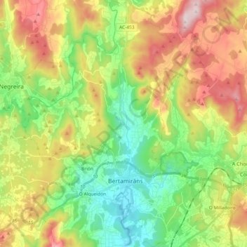
Name: Ames topographic map, elevation, terrain.

Location: Ames, Santiago, A Coruña, Galicia, Spain (42.82328 -8.72483 42.95768 -8.56531)

Average elevation: 218 m

Minimum elevation: 23 m

Maximum elevation: 525 m

Gear up for your next adventure:

🦶Anti-Blister Balm - Prevents friction and hotspots during long ascents
🚲Heavy Duty Bike Lock - Secure your bike at the trailhead or during stops
🧢Hiking Sun Hat - Wide-brimmed protection for exposed mountain ridges
🧳Compression Sacks - Maximize space in your backpack by shrinking gear
🧭Orienteering Kit - Tools for map reading and navigation in the wild

As an Amazon Associate, this site earns from qualifying purchases at no extra cost to you.