Geolocate

Argentona topographic map

Click on the map to display elevation.

About this map

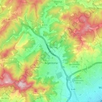
Name: Argentona topographic map, elevation, terrain.

Location: Argentona, Maresme, Barcelona, Catalonia, 08310, Spain (41.53048 2.35541 41.59531 2.42698)

Average elevation: 196 m

Minimum elevation: 3 m

Maximum elevation: 463 m

Gear up for your next adventure:

🔨Vehicle Emergency Tool - Safety tool for remote road trips to trailheads
💡LED Camping Lantern - Illuminate your campsite with long-lasting lanterns
🥾Trekking Poles - Adjustable trekking poles to reduce knee stress and improve stability
🥾Mountain Hiking Boots - High-traction boots for rocky terrain
Lightweight Backpacking Tent - Compact tent for efficient hiking trips

As an Amazon Associate, this site earns from qualifying purchases at no extra cost to you.