Geolocate

Macclesfield topographic map

Click on the map to display elevation.

About this map

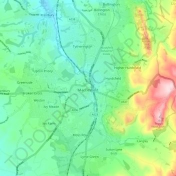
Name: Macclesfield topographic map, elevation, terrain.

Location: Macclesfield, Cheshire East, England, United Kingdom (53.23674 -2.18238 53.28586 -2.06967)

Average elevation: 182 m

Minimum elevation: 101 m

Maximum elevation: 388 m

Other topographic maps

Click on a map to view its topography, its elevation and its terrain.

Collins Wood

United Kingdom > England > Cheshire East

Average elevation: 91 m

Gear up for your next adventure:

🧦Hiking Socks - Moisture-wicking and comfortable socks for long hikes
🦶Hiking Shoe Insoles - Added support for high arches and long days on feet
🥾Durable Hiking Shoes - Long-lasting shoes for frequent hiking
🎒Hiking Backpack - Lightweight and ergonomic backpacks for day hikes or multi-day treks
👟Sport Hiking Sandals - Breathable footwear for water crossings and camp rest

As an Amazon Associate, this site earns from qualifying purchases at no extra cost to you.