Geolocate

Tiruppur topographic map

Click on the map to display elevation.

Tiruppur

Tiruppur is located at 11°06′27″N 77°20′23″E / 11.1075°N 77.3398°E / 11.1075; 77.3398 on the banks of the Noyyal River. It has an average elevation of 295 metres (967 feet) and covers an area of 159.6 km2 (61.6 sq mi).

Wikipedia (CC-BY-SA 3.0)

About this map

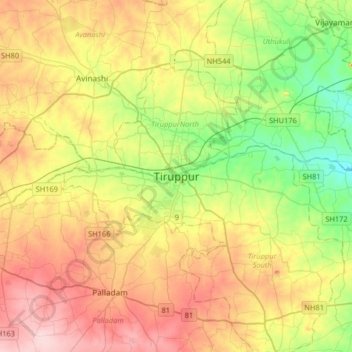
Name: Tiruppur topographic map, elevation, terrain.

Location: Tiruppur, Tiruppur South, Tiruppur, Tamil Nadu, 638600, India (10.94178 77.18519 11.26178 77.50519)

Average elevation: 334 m

Minimum elevation: 247 m

Maximum elevation: 439 m

Gear up for your next adventure:

🥘Camping Cookware Set - Compact nesting pots and pans for trail cooking
🍽️Titanium Camping Spork - Ultralight and indestructible eating utensil
🔥Emergency Fire Starter - Reliable ignition source for all weather conditions
👖Convertible Hiking Pants - Zip-off legs to adapt to changing weather conditions
Lightweight Camping Tent - Portable shelter optimized for Canadian backcountry camping

As an Amazon Associate, this site earns from qualifying purchases at no extra cost to you.