Geolocate

Saint-Louis topographic map

Click on the map to display elevation.

About this map

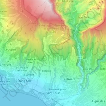
Name: Saint-Louis topographic map, elevation, terrain.

Location: Saint-Louis, Saint-Pierre, Réunion, France (-21.30332 55.38041 -21.14702 55.46445)

Average elevation: 723 m

Minimum elevation: 0 m

Maximum elevation: 2,557 m

Other topographic maps

Click on a map to view its topography, its elevation and its terrain.

Hell-Bourg

France > Réunion

Average elevation: 1,132 m

La Plaine Chabrier

France > Réunion > Saint-Paul

Average elevation: 26 m

Saint-Laurent

France > Réunion > La Possession

Average elevation: 126 m

Grand Bassin

France > Réunion > Le Tampon

Average elevation: 1,179 m

Ruisseau Blanc

France > Réunion > Saint-Denis

Average elevation: 385 m

Saint-Benoît

France > Réunion > Saint-Benoît > Saint-Benoît

Average elevation: 50 m

Marla

France > Réunion > Saint-Paul > Marla

Average elevation: 1,798 m

échelles

France > Réunion > Saint-Benoît

Average elevation: 1,008 m

Gear up for your next adventure:

Camping Tent - Weather-resistant tents suitable for 2 to 6 people
🥾Trail Running Shoes - Lightweight and durable shoes for trail running
🧴Insect Repellent - Protect yourself from bugs during outdoor adventures
🧴Bear Spray Holster - Quick-access carry for essential Canadian wilderness safety
🥾Waterproof Trail Shoes - Shoes designed to handle wet terrain

As an Amazon Associate, this site earns from qualifying purchases at no extra cost to you.